
Thursday 28 March 2024
Since announcing my LETJOG E2W challenge on Monday, I have been out for a couple of short walks to keep the legs moving, but I have spent rather more time at my desk refining my route and booking a few of my overnight stops for the first stage of the walk across East Anglia and the Fenlands of eastern England. A number of friends and family have asked me for details of my trek, and I can now share a bit more description of my intended journey for those interested.
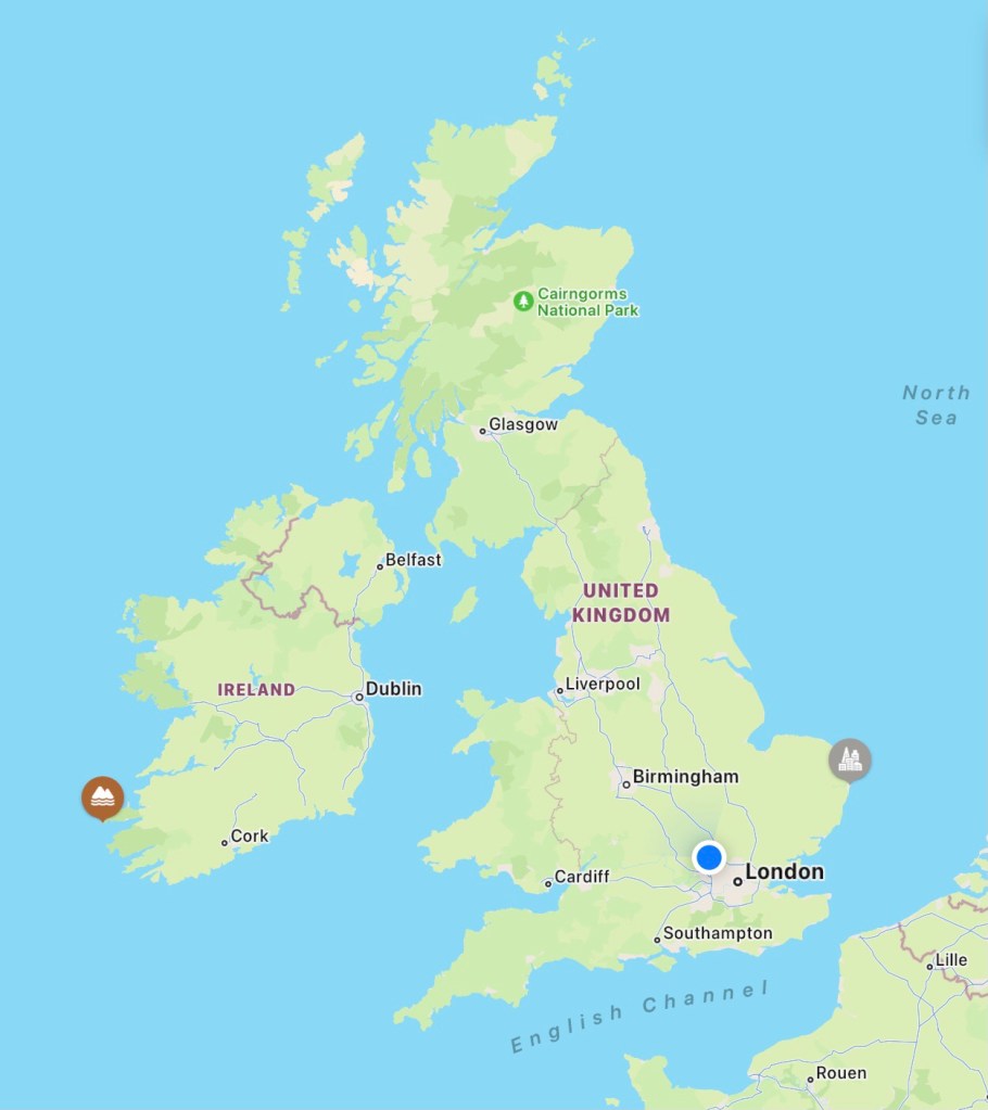
So, rather than photos of the outdoors, today I am sharing a few maps setting out my proposed route in more detail. The path is shown as a series of straight lines between the main centres through which I hope to pass, but in reality I am sure to take a more meandering course, along footpaths, minor lanes and common land where possible. It is similarly most unlikely that the nodal points on the maps will turn out to be my actual overnight stops, although I have used these locations in planning the various stages of my walk.
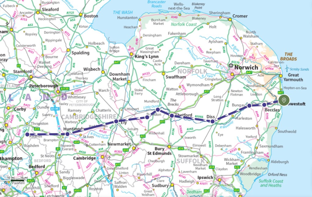
I have allowed eight days of walking for this first section of my E2W journey, across the broadlands, brecklands and fenlands of eastern England. My path will take me from Lowestoft Ness on the North Sea coast of Suffolk, inland and westwards for about 128 miles, to Raunds beside the River Nene in Northamptonshire. From this point the route rises slightly to the hills of the Midlands, but the first week itself promises some relatively easy walking across flat country under some huge skies. I will start off with a couple of fairly short days through Beccles and Bungay, and then as I get into my stride I will pass through Diss and Thetford in Norfolk, before crossing back into Suffolk through Brandon and Lakenheath and traversing Cambridgeshire via Ely and Huntingdon before continuing to Raunds.
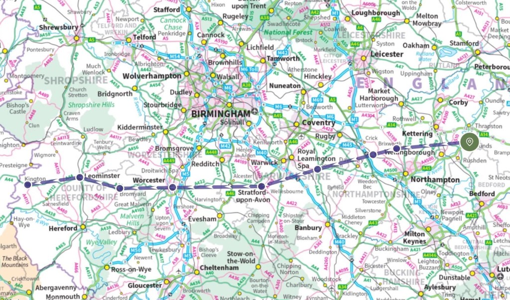
This second stage passes through some country that is rather more familiar to me, crossing Northamptonshire (from where I may take a train home for a day’s rest), then across Warwickshire via the towns of Southam and Stratford-Upon Avon, before passing Worcester (where I will cross my LETJOG 2021 route), and onward through the Herefordshire towns of Bromyard, Leominster and Kington. Close to the Welsh border, Kington will mark the completion of my second stage, a section of around 129 miles and about 2,400 metres of cumulative climb over eight walking days.
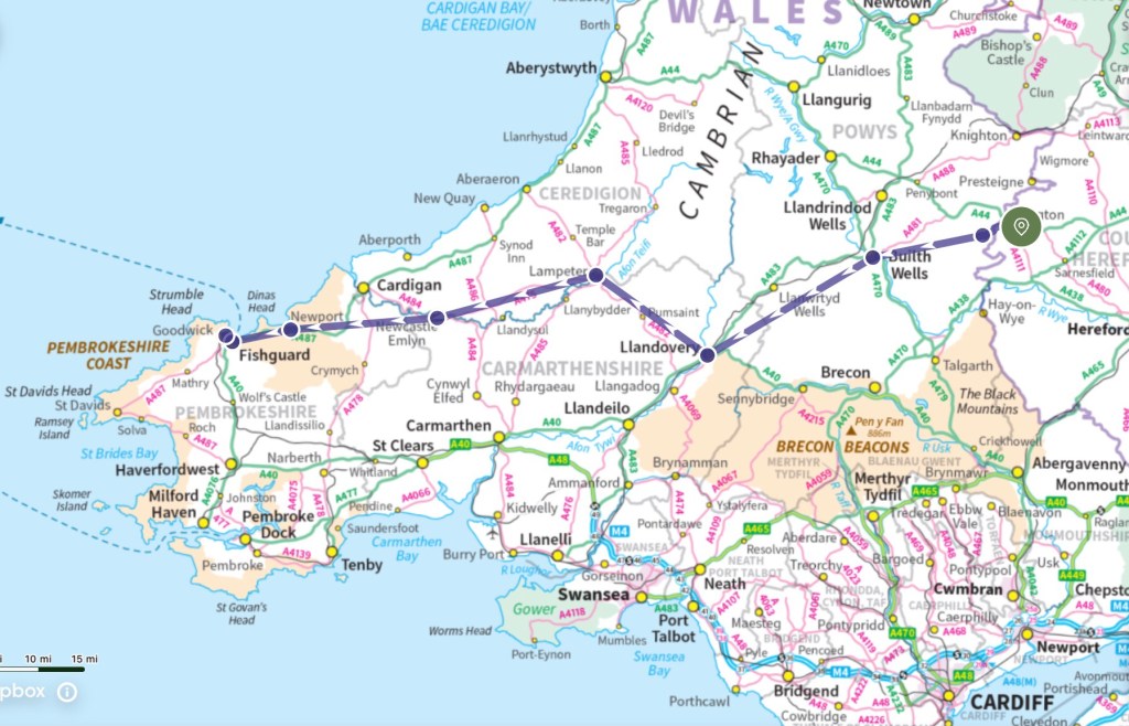
In many respects this middle section is the most demanding. The terrain is hilly, necessitating at least three long walking days of over 20 miles in crossing the remote hills. Opportunities for overnight stops are more limited than elsewhere, although I will pass through the towns of Builth Wells, Llandovery, Lampeter, Newcastle Emlyn and Newport on my way to the Irish Sea ferry port at Fishguard. I have allowed six days for this section, covering 118 miles and nearly 4,700 metres of climb, and with no rest days scheduled the walking is likely to be the most testing stage of the trek.
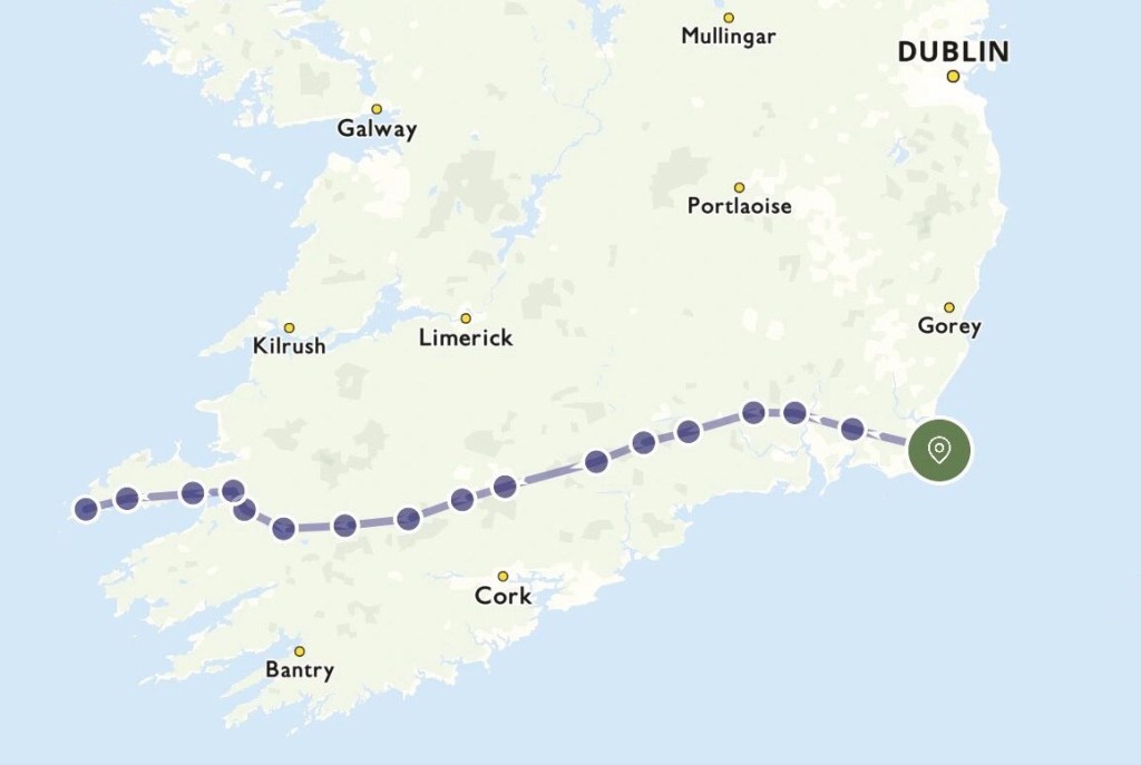
Ireland is not covered by the Ordnance Survey mapping service, and so I will not have the detailed route maps accessible on my phone in the same way as for the UK sections of the walk. This situation provides a challenge in itself, both now at the route planning stage and on the ground, where I might need to buy a series of conventional paper maps. There are many hilly sections on Ireland, and accommodation may be less easy to pre-book than in the UK, so I have planned for shorter walking days of around 14 miles on average to allow more time for finding a meal and a roof each evening. I have scheduled two Rest Days on Eire – one for the ferry crossing from Fishguard to Rosslare, and another for a short detour to Cork, on the south coast, around half way through my Ireland walk. Towards the end of the path, along the Dingle Peninsula, I am hoping that Rachel can join me for the final trek to Dunmore Head on the Atlantic coast, and then for a few days’ break to finish the trip in style.
This weekend, over Easter, with my family in Cornwall, I am planning some rambles on and around the South West Coast Path, that should also serve as part of my LETJOG E2W training and preparations. I will post some photos of our walks in the area during next week – until then I hope that you all enjoy a very Happy Easter!

I have taken my Blog heading for today ‘Song For The Road’ from the title of a number by Kent-born singer-songwriter David Ford that appears on his second studio album ‘Songs For The Road’, from 2007. Ford first achieved prominence as part of the indie rock band Easyworld, before going solo in 2005: he has since toured in support of many leading artists that include Elvis Costello and KT Tunstall. His lyrics to ‘Song For The Road’ include the words ‘I will sail over this countryside with friends new and old’, an image that certainly sets an appealing tone for my LETJOG E2W journey.
